


Spain Topo Maps

Deskripsi Spain Topo Maps
+++ Aplikasi Pemetaan GPS Baru +++
Aplikasi navigasi GPS Outdoor / Offline yang mudah digunakan dengan akses ke peta topografi terbaik dan gambar udara untuk Spanyol.
Termasuk Kepulauan Balearic dan Kepulauan Canary
++ Untuk penggunaan offline, fitur PRO diperlukan! ++
Ubah Ponsel Andoid Anda menjadi GPS luar ruangan untuk perjalanan ke pedalaman TANPA CELL COVERAGE. Aplikasi ini memberi Anda opsi pemetaan yang sama seperti yang Anda tahu dari perangkat GPS.
Termasuk lapisan peta GRATIS:
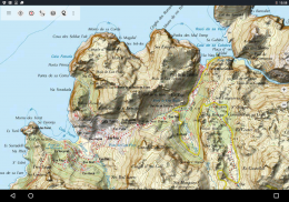
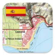
• Peta Topo Spanyol: Mapa Topográfico Nacional 1: 50.000 & 1: 25.000 (IGN MTN25 & MTN50)
• Peta Dasar IGN: Base Topográfica Nacional 1: 25.000 (BTN25 & BCN25)
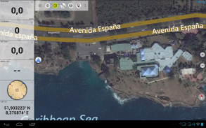
• Gambar Spanyol: Gambar udara resolusi tinggi. Plan Nacional de Ortofotografía Aérea (PNOA)
• Catalonia Topo Maps: Peta topografi resolusi tinggi untuk Catalonia
• Peta Pendaftaran Tanah: Cartografía Catastral
• OpenStreetMaps: Peta crowdsourced ini merupakan tambahan yang sangat berguna untuk lapisan peta lainnya. Berisi banyak fitur unik.
• OpenCycleMaps: Peta ini ideal untuk merencanakan perjalanan sepeda
• ESRI Topografi
• Gambar Udara ESRI
• Peta Jalan ESRI
• Google Road Map (hanya akses online)
• Gambar Google Satellite (hanya akses online)
• Google Terrain Map (hanya akses online)
• Peta Jalan Bing (hanya akses online)
• Gambar Satelit Bing (hanya akses online)
• Bumi Di Malam Hari
• Hamparan hillshading
Fitur utama untuk navigasi luar ruangan:
• Buat dan edit Waypoints
• GoTo-Waypoint-Navigasi
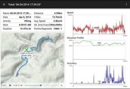
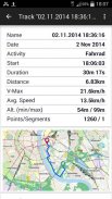
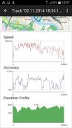
• Rekaman Track (dengan profil kecepatan, ketinggian, dan akurasi)
• Tripmaster dengan bidang untuk odometer, kecepatan rata-rata, bantalan, ketinggian, dll.
• Ekspor GPX / KML / KMZ
• Cari (nama tempat, tempat tujuan, jalan)
• Ladang data yang dapat dikustomisasi dalam Tampilan Peta dan Tripmaster (mis. Kecepatan, Jarak, Kompas, ...)
• Bagikan Waypoints, Tracks atau Routes (via eMail, Whatsapp, Dropbox, Facebook, ..)
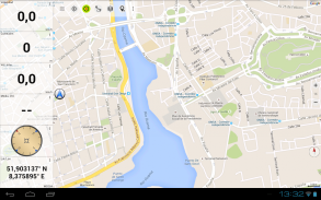
• Menampilkan koordinat dalam Lat / Lon, UTM atau MGRS / USNG (Grid Militer / Grid Nasional AS)
• Rekam & bagikan trek dengan statistik & profil ketinggian
• Putar peta (Track Up & North Up)
• Dapatkan Elevation dengan mengklik panjang pada peta
• Lacak Putar Ulang
• dan masih banyak lagi ...
Fitur Pro yang tersedia: (Fitur Pro tersedia melalui Pembelian Dalam Aplikasi)
• Penggunaan Offline - tidak diperlukan jangkauan sel
• Mudah + Cepat unduh Massal ubin peta untuk OFFLINE USAGE (bukan untuk Google dan peta Bing)
• Buat dan edit Rute
• Rute-Navigasi (Navigasi Point-to-Point)
• Impor GPX / KML / KMZ
• Waypoint & Tracks tanpa batas
• Tambahkan Map Tile-Server lainnya
• Tanpa iklan
Penggunaan Offline:
Semua petak peta yang dilihat disimpan dalam cache. Untuk melakukan cache pada area yang luas, Anda perlu membeli fitur Pro.
Gunakan aplikasi navigasi ini untuk kegiatan di luar ruangan seperti hiking, bersepeda, berkemah, memanjat, naik, ski, kano, berburu, wisata 4WD offroad atau pencarian & penyelamatan (SAR).
Tambahkan titik jalan khusus dalam format bujur / lintang, UTM atau MGRS / USNG dengan datum WGS84.
Impor / Ekspor / Bagikan GPS-Waypoints / Tracks / Rute dalam format GPX atau Google Earth KML / KMZ.
Muat ulang data peta GRATIS untuk area tanpa layanan seluler (fitur Pro!).
Komentar dan permintaan fitur ke spainmaps@atlogis.com
Lihat aplikasi navigasi luar ruang kami yang lain: https://play.google.com/store/search?q=atlogis
+++ Kami TIDAK melacak aktivitas pengguna atau mengumpulkan data pengguna apa pun! +++

Spain Topo Maps - Informasi APK
Versi APK: 7.5.1Paket: com.atlogis.spainVersi Terakhir dari Spain Topo Maps
Versi lain


 3.87
3.87


Aplikasi pada kategori yang sama

Anda juga mungkin suka...


